Processing math: 100%
Skip to main content
null
Findings
  • Menu
  • Articles
    • Energy Findings
    • Resilience Findings
    • Safety Findings
    • Transport Findings
    • Urban Findings
    • All
  • For Authors
  • Editorial Board
  • About
  • Blog
  • covid-19
  • search

RSS Feed

Enter the URL below into your favorite RSS reader.

http://localhost:22663/feed
Transport Findings
August 14, 2024 AEST

A Review of the Structure of Street Networks

Marc Barthelemy, Geoff Boeing,
street networksroad networksspatial networksliterature review
Copyright Logoccby-sa-4.0 • https://doi.org/10.32866/001c.122117
Findings
Barthelemy, Marc, and Geoff Boeing. 2024. “A Review of the Structure of Street Networks.” Findings, August. https:/​/​doi.org/​10.32866/​001c.122117.
Save article as...▾
Download all (5)
  • Figure 1. Street networks with (a) small average degree (Helsinki ¯k=2.35), (b) typical value (Singapore ¯k=3.0), and (c) a large value (Buenos Aires ¯k=3.55). The overall organization of street networks is diverse, reflecting a wide range of patterns and structures depending on urban planning, geography, and cultural factors (see the Supp. Info. for details about the degree k calculation).
    Download
  • Figure 2. Spatial distribution of node betweenness centrality (weighted by edge length) for Beijing, China (yellow nodes are more central). We observe the emergence of non-trivial patterns of large BC nodes (Data from OSM).
    Download
  • Figure 3. Polar histograms (bar directions represent streets’ compass bearings and bar lengths represent relative frequency of streets) and the corresponding street maps illustrating different types of organization: low entropy (Chicago), typical (New Orleans), and high entropy (Rome).
    Download
  • Supp. Info
    Download
  • Manuscript File
    Download

Sorry, something went wrong. Please try again.

If this problem reoccurs, please contact Scholastica Support

Error message:

undefined

View more stats

Abstract

We review measures of street network structure proposed in the recent literature, establish their relevance to practice, and identify open challenges facing researchers. These measures’ empirical values vary substantially across world regions and development eras, indicating street networks’ geometric and topological heterogeneity.

1. Questions

Street networks shape the movement of people and goods through cities. Researchers model them to analyze network performance, predict traffic patterns, and evaluate infrastructure investments. Measures proposed in the recent network science literature alongside worldwide urban data availability can improve our understanding of these systems. How can we measure the spatial and topological structure of urban street networks to characterize the diversity of city organization worldwide?

2. Methods

Researchers usually model street networks as graphs where nodes are intersections and edges are street segments between intersections. This is the commonly accepted procedure, but it is not trivial, as discussed in Marshall et al. (2018). Data for contemporary streets and roads are often available from governmental sources as well as OpenStreetMap (OSM), a free, open worldwide geographic database updated and maintained by volunteers. Tools such as OSMnx (Boeing 2024) render street network analysis fast and easy, using OSM data. We review papers from the past 20 years across the geography, engineering, planning, and physics literatures that propose structural measures. Then we compare their empirical findings around the world.

3. Results

Various properties of these networks were studied over the past two decades, e.g. Cardillo et al. (2006); Buhl et al. (2006); Xie and Levinson (2007); Crucitti, Latora, and Porta (2006); Barthelemy and Flammini (2008); Lämmer, Gehlsen, and Helbing (2006); Barthelemy et al. (2013); Strano et al. (2012); Louf and Barthelemy (2014); Levinson (2012); Kirkley et al. (2018); Chen et al. (2024); Gudmundsson and Mohajeri (2013); Jiang (2007); Scellato et al. (2006); Masucci et al. (2009); Rosvall et al. (2005), and here we will focus on the most important indicators. The temporal evolution of these structures is also studied, thanks to the digitalization of historical data (Perret, Gribaudi, and Barthelemy 2015; Strano et al. 2012; Masucci, Stanilov, and Batty 2013; Barthelemy et al. 2013; Burghardt et al. 2022; Barrington-Leigh and Millard-Ball 2015).

Due to strong physical constraints, many quantities studied in complex networks (Latora, Nicosia, and Russo 2017; Menczer, Fortunato, and Davis 2020) are not relevant for street networks (Lämmer, Gehlsen, and Helbing 2006; Mossa et al. 2002). For example, street networks have a narrow degree distribution and a very high clustering coefficient (Barthelemy 2022). Also, many indicators introduced in transportation geography, such as alpha, beta, and gamma indices (Kansky 1963), mainly depend on the average degree and are redundant. To effectively characterize street networks, it is also crucial to consider spatial properties such as planarity, road segment length distribution, betweenness centrality spatial distribution, block shape factor, and street angle distribution. We will present here results for what could constitute a minimal set of measures that characterizes a street network.

The most basic indicator, the number of nodes, increases with the population - which makes theoretical sense as residents can share public infrastructure - at most linearly (Strano et al. 2012; Barthelemy et al. 2013), and in general slightly sublinearly (Boeing 2022): a 1% increase in urban area population is associated with a 0.95% (±0.03%) increase in intersection count. The total length scales accordingly to a simple argument (Barthelemy and Flammini 2008) as √AN where A is the area size. Basic measures (see Supp. Info. for the definition of all quantities discussed) which convey important information about these networks are summarized in Table 1 for 100 world cities.

Table 1.Basic network statistics computed for the set of 100 world cities discussed in (Boeing 2019): average degree ¯k, proportion of dead-ends p1, proportion p4 of k=4 intersections, average length l1 (in meters) of edges.
Quantity ¯k p1 p4 l1
range [2.30,3.55] 2%-39% 4%-59% [64.5,537.5]
median 2.93 14% 18% 118.6

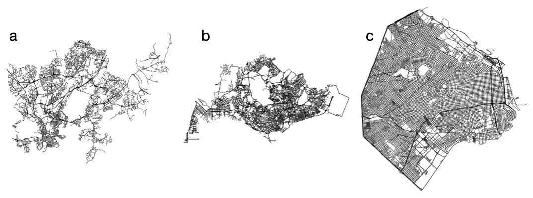
We observe for all measures a large diversity of values and illustrate the possible networks according to their average degree value in Figure 1.

Figure 1
Figure 1.Street networks with (a) small average degree (Helsinki ¯k=2.35), (b) typical value (Singapore ¯k=3.0), and (c) a large value (Buenos Aires ¯k=3.55). The overall organization of street networks is diverse, reflecting a wide range of patterns and structures depending on urban planning, geography, and cultural factors (see the Supp. Info. for details about the degree k calculation).

These networks are not completely planar due to the presence of tunnels and bridges. A measure, the Spatial Planarity Ratio, φ was introduced in Boeing (2020): a spatially planar network with no overpasses or underpasses will have φ=1.0, while lower values indicate the extent to which the network is planar. Among drivable street networks for 50 world cities, only 20% are formally planar and on average φ=0.88, and ranging from 100% in six of these cities to a low of 54% for Moscow.

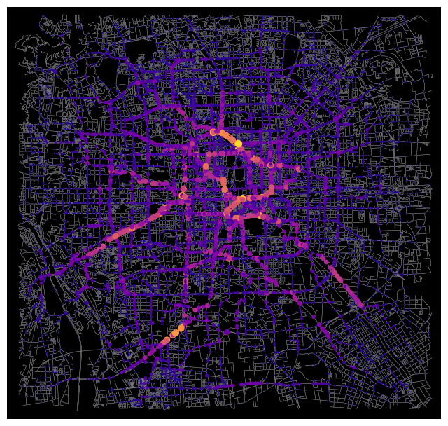
The betweenness centrality (BC) defined in (Freeman 1977) measures the importance of a node (or edge) for flows on the network. In this sense it could serve as a simple proxy for traffic on the network (although it assumes in general a flat OD matrix), but also as an interesting structural probe of the network. The distribution of betweenness centrality (BC) is invariant for street networks, despite the existence of structural differences between them (Kirkley et al. 2018). For a regular network, the BC decreases with the distance to the gravity center of nodes, but when disorder is present, we observe the emergence of different patterns. In particular, we observe the presence of loops with large BC (Lion and Barthelemy 2017; Barthelemy et al. 2013) signaling the importance of these structures for large cities (see Figure 2).

Figure 2
Figure 2.Spatial distribution of node betweenness centrality (weighted by edge length) for Beijing, China (yellow nodes are more central). We observe the emergence of non-trivial patterns of large BC nodes (Data from OSM).

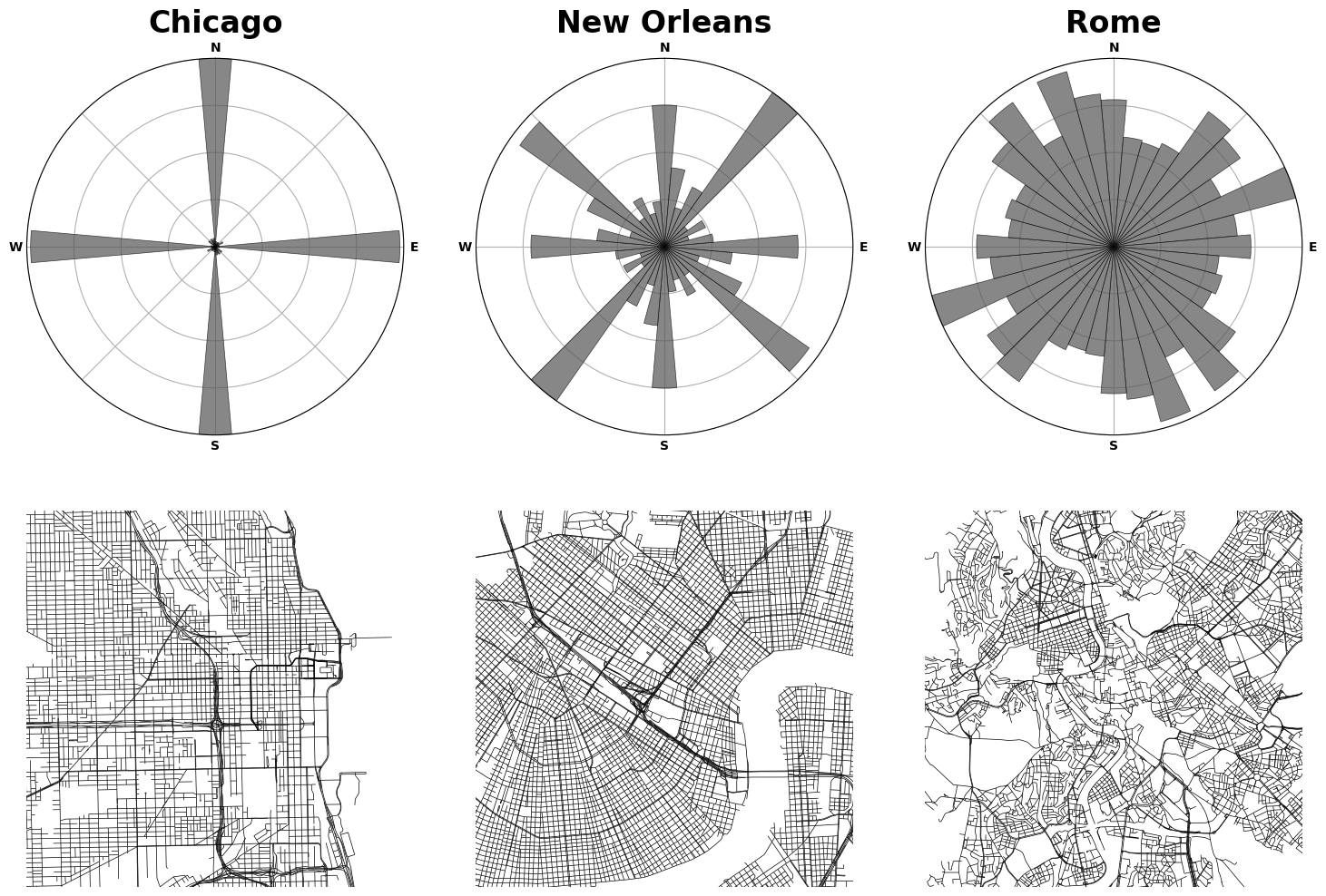
The geometry of street networks is also fundamental. Using a large global database comprising all major roads on the Earth, Strano et al. (2017) showed that the road length distribution within croplands is indistinguishable from urban ones, once rescaled by the average road length. The area a of blocks is another important feature of these spatial networks, and it was shown that its distribution is universal of the form P(a)∼a−2 (Lämmer, Gehlsen, and Helbing 2006; Louf and Barthelemy 2014). The organization and overall geometry of the street network can also be characterized by the distribution of street angles. There are very regular networks (almost lattice like) such as in Chicago and very disordered ones such as in Rome (Figure 3). The orientation order can then be characterized by the entropy of street compass bearings (Boeing 2019).

Figure 3
Figure 3.Polar histograms (bar directions represent streets’ compass bearings and bar lengths represent relative frequency of streets) and the corresponding street maps illustrating different types of organization: low entropy (Chicago), typical (New Orleans), and high entropy (Rome).

Finally, several authors proposed to construct a typology of these street networks: Marshall (2004) proposed a first approach based on general considerations, a typology based on the block size distribution and shape was proposed in Louf and Barthelemy (2014), and more recently machine learning approaches were proposed. In Thompson et al. (2020) a greater proportion of railed public transport networks combined with dense road networks characterised by smaller blocks is correlated with the lowest rates of road traffic injury, and in Boeing, Pilgram, and Lu (2024) it was shown that straighter, more-connected, and less-overbuilt street networks are associated with lower transport emissions, all else equal.

This review covers a minimal set of topological and spatial measures of street network structure: node count, average degree, fraction of dead ends and intersections, average edge length, planarity index, BC spatial distribution, street angle distribution. Despite the universality of street networks, these measures show the diversity of structural patterns of streets reflecting local culture, politics, era, and transport technologies. Important challenges remain open. First, we need a better understanding of the spatio-temporal evolution of these networks and their co-evolution with cities (Capel-Timms et al. 2024). More efforts in the digitization of historical maps are needed to advance our theoretical understanding and modeling of this phenomenon. Second, merely identifying empirical values is not enough for the professional disciplines of city-making. A key future challenge is to link the “what” (descriptive measures) to the “how” to build new and improve existing networks to meet broader societal goals (sustainability, resilience, public health, economic health, etc).

Submitted: July 07, 2024 AEST

Accepted: August 01, 2024 AEST

References

Barrington-Leigh, C., and A. Millard-Ball. 2015. “A Century of Sprawl in the United States.” Proceedings of the National Academy of Sciences 112 (27): 8244–49. https:/​/​doi.org/​10.1073/​pnas.1504033112.
Google ScholarPubMed CentralPubMed
Barthelemy, M. 2022. Spatial Networks: A Complete Introduction: From Graph Theory and Statistical Physics to Real-World Applications. Heidelberg: Springer Nature. https:/​/​doi.org/​10.1007/​978-3-030-94106-2.
Google Scholar
Barthelemy, M., P. Bordin, H. Berestycki, and M. Gribaudi. 2013. “Self-Organization versus Top-down Planning in the Evolution of a City.” Scientific Reports 3 (1): 2153. https:/​/​doi.org/​10.1038/​srep02153.
Google ScholarPubMed CentralPubMed
Barthelemy, M., and A. Flammini. 2008. “Modeling Urban Street Patterns.” Physical Review Letters 100 (13): 138702. https:/​/​doi.org/​10.1103/​PhysRevLett.100.138702.
Google Scholar
Boeing, G. 2019. “Urban Spatial Order: Street Network Orientation, Configuration, and Entropy.” Applied Network Science 4 (1): 1–9. https:/​/​doi.org/​10.1007/​s41109-019-0189-1.
Google Scholar
———. 2020. “Planarity and Street Network Representation in Urban Form Analysis.” Environment and Planning B: Urban Analytics and City Science 47 (5): 855–69. https:/​/​doi.org/​10.1177/​2399808318802941.
Google Scholar
———. 2022. “Street Network Models and Indicators for Every Urban Area in the World.” Geographical Analysis 54 (3): 519–35. https:/​/​doi.org/​10.1111/​gean.12281.
Google Scholar
———. 2024. “Modeling and Analyzing Urban Networks and Amenities with OSMnx.” Working paper. https:/​/​geoffboeing.com/​publications/​osmnx-paper/​.
Boeing, G., C. Pilgram, and Y. Lu. 2024. “Urban Street Network Design and Transport-Related Greenhouse Gas Emissions around the World.” Transportation Research Part D: Transport and Environment 127:103961. https:/​/​doi.org/​10.1016/​j.trd.2023.103961.
Google Scholar
Buhl, J., J. Gautrais, N. Reeves, R. V. Solé, S. Valverde, P. Kuntz, and G. Theraulaz. 2006. “Topological Patterns in Street Networks of Self-Organized Urban Settlements.” The European Physical Journal B 49:513–22. https:/​/​doi.org/​10.1140/​epjb/​e2006-00085-1.
Google Scholar
Burghardt, K., J. Uhl, K. Lerman, and S. Leyk. 2022. “Road Network Evolution in the Urban and Rural United States since 1900.” Computers, Environment and Urban Systems 95 (July):101803.
Google Scholar
Capel-Timms, I., D. Levinson, B. Lahoorpoor, S. Bonetti, and G. Manoli. 2024. “The Angiogenic Growth of Cities.” Journal of the Royal Society Interface 21 (213): 0230657. https:/​/​doi.org/​10.1098/​rsif.2023.0657.
Google ScholarPubMed CentralPubMed
Cardillo, A., S. Scellato, V. Latora, and S. Porta. 2006. “Structural Properties of Planar Graphs of Urban Street Patterns.” Physical Review E 73 (6): 066107. https:/​/​doi.org/​10.1103/​PhysRevE.73.066107.
Google Scholar
Chen, W., H. Huang, S. Liao, F. Gao, and F. Biljecki. 2024. “Global Urban Road Network Patterns: Unveiling Multiscale Planning Paradigms of 144 Cities with a Novel Deep Learning Approach.” Landscape and Urban Planning 241:104901. https:/​/​doi.org/​10.1016/​j.landurbplan.2023.104901.
Google Scholar
Crucitti, P., V. Latora, and S. Porta. 2006. “Centrality Measures in Spatial Networks of Urban Streets.” Physical Review E 73 (3): 036125. https:/​/​doi.org/​10.1103/​PhysRevE.73.036125.
Google Scholar
Freeman, L. 1977. “A Set of Measures of Centrality Based on Betweenness.” Sociometry 1:35–41. https:/​/​doi.org/​10.2307/​3033543.
Google Scholar
Gudmundsson, A., and N. Mohajeri. 2013. “Entropy and Order in Urban Street Networks.” Scientific Reports 3 (1): 3324. https:/​/​doi.org/​10.1038/​srep03324.
Google ScholarPubMed CentralPubMed
Jiang, B. 2007. “A Topological Pattern of Urban Street Networks: Universality and Peculiarity.” Phys. A 384:647–55. https:/​/​doi.org/​10.1016/​j.physa.2007.05.064.
Google Scholar
Kansky, K. 1963. Structure of Transportation Networks. Chicago, Illinois: University of Chicago.
Google Scholar
Kirkley, A., H. Barbosa, M. Barthelemy, and G. Ghoshal. 2018. “From the Betweenness Centrality in Street Networks to Structural Invariants in Random Planar Graphs.” Nature Communications 9 (1): 2501. https:/​/​doi.org/​10.1038/​s41467-018-04978-z.
Google ScholarPubMed CentralPubMed
Lämmer, S., B. Gehlsen, and D. Helbing. 2006. “Scaling Laws in the Spatial Structure of Urban Road Networks.” Physica A: Statistical Mechanics and Its Applications 363 (1): 89–95. https:/​/​doi.org/​10.1016/​j.physa.2006.01.051.
Google Scholar
Latora, V., V. Nicosia, and G. Russo. 2017. Complex Networks: Principles, Methods and Applications. Cambridge UK: Cambridge University Press. https:/​/​doi.org/​10.1017/​9781316216002.
Google Scholar
Levinson, D. 2012. “Network Structure and City Size.” PLoS ONE 7 (1): e29721. https:/​/​doi.org/​10.1371/​journal.pone.0029721.
Google ScholarPubMed CentralPubMed
Lion, B., and M. Barthelemy. 2017. “Central Loops in Random Planar Graphs.” Physical Review E 4:042310. https:/​/​doi.org/​10.1103/​PhysRevE.95.042310.
Google Scholar
Louf, R., and M. Barthelemy. 2014. “A Typology of Street Patterns.” Journal of the Royal Society Interface 11 (101): 20140924. https:/​/​doi.org/​10.1098/​rsif.2014.0924.
Google ScholarPubMed CentralPubMed
Marshall, S. 2004. Streets and Patterns. Routledge. https:/​/​doi.org/​10.4324/​9780203589397.
Google Scholar
Marshall, S., J. Gil, K. Kropf, M. Tomko, and L. Figueiredo. 2018. “Street Network Studies: From Networks to Models and Their Representations.” Networks and Spatial Economics 18:735–49. https:/​/​doi.org/​10.1007/​s11067-018-9427-9.
Google Scholar
Masucci, A., D. Smith, A. Crooks, and M. Batty. 2009. “Random Planar Graphs and the London Street Network.” Eur. Phys. J. B 71:259–71. https:/​/​doi.org/​10.1140/​epjb/​e2009-00290-4.
Google Scholar
Masucci, A., K. Stanilov, and M. Batty. 2013. “Limited Urban Growth: London’s Street Network Dynamics since the 18th Century.” PLoS One 8 (8): e69469. https:/​/​doi.org/​10.1371/​journal.pone.0069469.
Google ScholarPubMed CentralPubMed
Menczer, F., S. Fortunato, and C. Davis. 2020. A First Course in Network Science. Cambridge, UK: Cambridge University Press. https:/​/​doi.org/​10.1017/​9781108653947.
Google Scholar
Mossa, S., M. Barthelemy, H. Stanley, and L. Amaral. 2002. “Truncation of Power Law Behavior in ‘Scale-Free’ Network Models Due to Information Filtering.” Physical Review Letters 88 (13): 138701. https:/​/​doi.org/​10.1103/​PhysRevLett.88.138701.
Google Scholar
Perret, J., M. Gribaudi, and M. Barthelemy. 2015. “Roads and Cities of 18th Century France.” Scientific Data 2 (1): 1–7. https:/​/​doi.org/​10.1038/​sdata.2015.48.
Google ScholarPubMed CentralPubMed
Rosvall, M., A. Trusina, P. Minnhagen, and K. Sneppen. 2005. “Networks and Cities: An Information Perspective.” Physical Review Letters 94 (2): 028701. https:/​/​doi.org/​10.1103/​PhysRevLett.94.028701.
Google Scholar
Scellato, S., A. Cardillo, V. Latora, and S. Porta. 2006. “The Backbone of a City.” Eur. Phys. J. B 50:221–25. https:/​/​doi.org/​10.1140/​epjb/​e2006-00066-4.
Google Scholar
Strano, E., A. Giometto, S. Shai, E. Bertuzzo, P. J. Mucha, and A. Rinaldo. 2017. “The Scaling Structure of the Global Road Network.” Royal Society Open Science 4 (10): 170590. https:/​/​doi.org/​10.1098/​rsos.170590.
Google ScholarPubMed CentralPubMed
Strano, E., V. Nicosia, V. Latora, S. Porta, and M. Barthelemy. 2012. “Elementary Processes Governing the Evolution of Road Networks.” Scientific Reports 2 (1): 296. https:/​/​doi.org/​10.1038/​srep00296.
Google ScholarPubMed CentralPubMed
Thompson, J., M. Stevenson, J. S. Wijnands, K. A. Nice, G. D. Aschwanden, J. Silver, M. Nieuwenhuijsen, et al. 2020. “A Global Analysis of Urban Design Types and Road Transport Injury: An Image Processing Study.” The Lancet Planetary 4 (1): 32–42. https:/​/​doi.org/​10.1016/​S2542-5196(19)30263-3.
Google ScholarPubMed CentralPubMed
Xie, F., and D. Levinson. 2007. “Measuring the Structure of Road Networks.” Geographical Analysis 39 (3): 336–56. https:/​/​doi.org/​10.1111/​j.1538-4632.2007.00707.x.
Google Scholar

This website uses cookies

We use cookies to enhance your experience and support COUNTER Metrics for transparent reporting of readership statistics. Cookie data is not sold to third parties or used for marketing purposes.

Powered by Scholastica, the modern academic journal management system