1. QUESTIONS
Why do more people die per capita nearly every year in the most southern 15 US states, than in the other states? And why are so many dying at in the south if it has better light conditions/visibility throughout the year? Are they walking more at night? Driving more? Driving more dangerously?
Pedestrians make up 17% of US roadway deaths, and this number is rising (NHTSA, 2021). US pedestrian death rates are 2 to 3 times higher per capita and 5 to 10 times higher per walked-mile than those in Western European nations (Buehler and Pucher 2021). While 10.5% of US person-trips are made by walking, walking distances are just 0.85% of Americans’ person-miles traveled (PMT) (FHWA 2017).
Roughly 75% of US pedestrian deaths occur after sunset and before sunrise (during “nighttime”), with the death count almost doubling between 2009 and 2018 (Retting 2020; Tefft, Arnold, and Horrey 2021). Darkness and nighttime conditions come with much higher frequency and severity of pedestrian injuries (Rahman, Kockelman, and Perrine 2022; Zhao et al. 2023). Arizona, California, Florida, Georgia and Texas (all relatively southern US states) accounted for 47% of all US pedestrian deaths while representing just 33% of the nation’s population (Retting 2020). The top 15 states with the highest pedestrian fatality rates are in the nation’s southern latitudes (NHTSA, 2019; 2022), with New Mexico topping the list, at almost 4 pedestrian deaths per year per 100,000 population. When dividing fatalities by vehicle-miles traveled (VMT), eight of the top ten US states are relatively southern, with Nevada and Arizona taking the lead (NHTSA, 2022).
This study examines the various demographic, location/position, time of day and year attributes that characterize Americans’ walk-miles traveled (WMT), in order to offer daytime vs nighttime WMT values for crash rate comparisons. The 2016/17 National Household Travel Survey (NHTS) data are used in hurdle regression models to predict each respondent’s WMT and nighttime WMT on his/her survey day.
2. METHODS
The 2016/17 NHTS dataset contains almost 924,000 person-trips made by nearly 130,000 U.S. households with 264,000 persons from mid-April 2016 through April 2017. Walk trip distances are capped here at 5 km (3 miles) to avoid very long hikes and runs that are not normally near roadways (or were misreported to the NHTS survey team). Each walk-trip’s starting position timing is key, since 75% of US pedestrian deaths occur in darkness (Retting 2020). Python’s ‘Suntime’ library was used to find sunset and sunrise to determine whether walk-trip start times were before sunrise or after sunset. Table 1 summarizes statistics for all variables used, after applying NHTS population weights.
Table 1.Summary Statistics of 2016/17 NHTS Person Records (n = 254,295 respondents)
|
Mean |
Median |
Std Dev |
Min |
Max |
| WMT = Respondent Walk-Miles (on sample day) |
0.207 |
0 |
1.777 |
0 |
270.701459 |
| WMT at "Night" (before sunrise + after sunset) |
0.015 |
0 |
0.394 |
0 |
74.5074911 |
| Age (in years)/10 |
4.843 |
5.2 |
2.179 |
0.5 |
9.2 |
| Male* |
0.473 |
0 |
0.499 |
0 |
1 |
| White* |
0.815 |
1 |
0.388 |
0 |
1 |
| African American* |
0.074 |
0 |
0.261 |
0 |
1 |
| Asian* |
0.046 |
0 |
0.210 |
0 |
1 |
| Other Race* |
0.065 |
0 |
0.247 |
0 |
1 |
| Worker (includes Full-time and Part-time workers)* |
0.597 |
1 |
0.490 |
0 |
1 |
| No High School or College Degree* |
0.161 |
0 |
0.368 |
0 |
1 |
| High School Graduate* |
0.180 |
0 |
0.384 |
0 |
1 |
| Some college (e.g., Assoc degree)* |
0.263 |
0 |
0.440 |
0 |
1 |
| Bachelor's degree* |
0.211 |
0 |
0.408 |
0 |
1 |
| Graduate degree* |
0.186 |
0 |
0.389 |
0 |
1 |
| Household Income/ $10,000 (over prior 12 months) |
8.247 |
6.25 |
5.558 |
1 |
20 |
| Daylight on Survey Day (hours) based on origin of first trip |
12.013 |
12 |
1.781 |
2 |
22 |
| Sunday* |
0.112 |
0 |
0.316 |
0 |
1 |
| Monday* |
0.154 |
0 |
0.361 |
0 |
1 |
| Tuesday* |
0.155 |
0 |
0.362 |
0 |
1 |
| Wednesday* |
0.154 |
0 |
0.361 |
0 |
1 |
| Thursday* |
0.159 |
0 |
0.365 |
0 |
1 |
| Friday* |
0.157 |
0 |
0.364 |
0 |
1 |
| Saturday* |
0.109 |
0 |
0.311 |
0 |
1 |
| Summer (June - August)* |
0.258 |
0 |
0.438 |
0 |
1 |
| Winter (December - February)* |
0.269 |
0 |
0.444 |
0 |
1 |
| Spring (March - May)* |
0.205 |
0 |
0.403 |
0 |
1 |
| Fall (September - November)* |
0.268 |
0 |
0.443 |
0 |
1 |
| Southern States (< 40° Latitude)* |
0.636 |
1 |
0.481 |
0 |
1 |
| Northern States (> 40° Latitude)* |
0.364 |
0 |
0.481 |
0 |
1 |
| Hawaii (Trip Origin < 25° Latitude )* |
0.003 |
0 |
0.050 |
0 |
1 |
| 25° - 30° Latitude (Trip Origin)* |
0.092 |
0 |
0.290 |
0 |
1 |
| 30° - 35° Latitude (Trip Origin)* |
0.321 |
0 |
0.467 |
0 |
1 |
| 35° - 40° Latitude (Trip Origin)* |
0.220 |
0 |
0.414 |
0 |
1 |
| 40° - 45° Latitude (Trip Origin)* |
0.340 |
0 |
0.474 |
0 |
1 |
| 45° - 50° Latitude (Trip Origin)* |
0.022 |
0 |
0.148 |
0 |
1 |
| Alaska (Trip Origin > 50° Latitude)* |
0.002 |
0 |
0.042 |
0 |
1 |
| West Coast Trip Origin (-125º> Longitude)* |
0.152 |
0 |
0.359 |
0 |
1 |
| Central U.S Trip Origin (-125º to -85º Longitude)* |
0.459 |
0 |
0.498 |
0 |
1 |
| East Coast Trip Origin (-85º< Longitude)* |
0.389 |
0 |
0.487 |
0 |
1 |
| Alabama Resident* |
0.003 |
0 |
0.050 |
0 |
1 |
| Alaska Resident* |
0.002 |
0 |
0.042 |
0 |
1 |
| Arizona Resident* |
0.022 |
0 |
0.147 |
0 |
1 |
| Arkansas Resident* |
0.002 |
0 |
0.039 |
0 |
1 |
| California Resident* |
0.203 |
0 |
0.402 |
0 |
1 |
| Colorado Resident* |
0.004 |
0 |
0.060 |
0 |
1 |
| Connecticut Resident* |
0.002 |
0 |
0.042 |
0 |
1 |
| Delaware Resident* |
0.002 |
0 |
0.044 |
0 |
1 |
| Wash. D.C. Resident* |
0.002 |
0 |
0.044 |
0 |
1 |
| Florida Resident* |
0.010 |
0 |
0.102 |
0 |
1 |
| Georgia Resident* |
0.067 |
0 |
0.250 |
0 |
1 |
| Hawaii Resident* |
0.002 |
0 |
0.047 |
0 |
1 |
| Idaho Resident* |
0.003 |
0 |
0.054 |
0 |
1 |
| Illinois Resident* |
0.008 |
0 |
0.087 |
0 |
1 |
| Indiana Resident* |
0.004 |
0 |
0.061 |
0 |
1 |
| Iowa Resident* |
0.021 |
0 |
0.143 |
0 |
1 |
| Kansas Resident* |
0.002 |
0 |
0.046 |
0 |
1 |
| Kentucky Resident* |
0.002 |
0 |
0.049 |
0 |
1 |
| Louisiana Resident* |
0.002 |
0 |
0.042 |
0 |
1 |
| Maine Resident* |
0.002 |
0 |
0.050 |
0 |
1 |
| Maryland Resident* |
0.011 |
0 |
0.106 |
0 |
1 |
| Massachusetts Resident* |
0.004 |
0 |
0.061 |
0 |
1 |
| Michigan Resident* |
0.006 |
0 |
0.077 |
0 |
1 |
| Minnesota Resident* |
0.005 |
0 |
0.069 |
0 |
1 |
| Mississippi Resident* |
0.002 |
0 |
0.040 |
0 |
1 |
| Missouri Resident* |
0.004 |
0 |
0.060 |
0 |
1 |
| Montana Resident* |
0.002 |
0 |
0.050 |
0 |
1 |
| Nebraska Resident* |
0.002 |
0 |
0.047 |
0 |
1 |
| Nevada Resident* |
0.002 |
0 |
0.039 |
0 |
1 |
| New Hamp. Resident* |
0.002 |
0 |
0.046 |
0 |
1 |
| New Jersey Resident* |
0.004 |
0 |
0.067 |
0 |
1 |
| New Mexico Resident* |
0.002 |
0 |
0.042 |
0 |
1 |
| New York Resident* |
0.130 |
0 |
0.336 |
0 |
1 |
| N Carolina Resident* |
0.067 |
0 |
0.249 |
0 |
1 |
| N Dakota Resident* |
0.002 |
0 |
0.047 |
0 |
1 |
| Ohio Resident* |
0.008 |
0 |
0.088 |
0 |
1 |
| Oklahoma Resident* |
0.010 |
0 |
0.098 |
0 |
1 |
| Oregon Resident* |
0.003 |
0 |
0.055 |
0 |
1 |
| Pennsylvania Resident* |
0.008 |
0 |
0.089 |
0 |
1 |
| Rhode Island Resident* |
0.002 |
0 |
0.041 |
0 |
1 |
| S Carolina Resident* |
0.053 |
0 |
0.223 |
0 |
1 |
| S Dakota Resident* |
0.002 |
0 |
0.049 |
0 |
1 |
| Tennessee Resident* |
0.004 |
0 |
0.059 |
0 |
1 |
| Texas Resident* |
0.195 |
0 |
0.396 |
0 |
1 |
| Utah Resident* |
0.003 |
0 |
0.055 |
0 |
1 |
| Vermont Resident* |
0.003 |
0 |
0.053 |
0 |
1 |
| Virginia Resident* |
0.005 |
0 |
0.073 |
0 |
1 |
| Washington Resident* |
0.005 |
0 |
0.070 |
0 |
1 |
| West Virginia Resident* |
0.002 |
0 |
0.042 |
0 |
1 |
| Wisconsin Resident* |
0.089 |
0 |
0.284 |
0 |
1 |
| Wyoming Resident* |
0.002 |
0 |
0.045 |
0 |
1 |
Note: Most covariates are indicator variables (represented by *), with 0/1 values, so their means lie between 0 and 1, and their medians are typically 0.
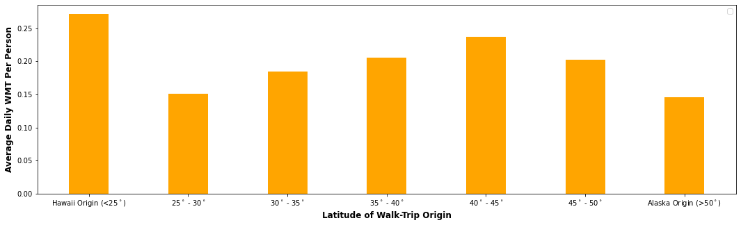
Figures 1 and 2 highlight different WMT choices by month of year and latitude. Unexpectedly, those living in northern US locations (above 40° latitude) walk more than those in southern (continental) settings, even though those in the northern locations experience up to 12% less daylight during the non-summer months (and up to 7% more daylight during summer months) when comparing daylight hours between 35° N and 45° N latitudes (United States Naval Observatory 2019).

Figure 1.Average WMT per Person per Day by Trip Origin
Figure 2 compares average WMT per person by month for walk trips in northern vs southern US settings. Average WMT ranges from about 0.15 to 0.30 per person-day, across months and locations, and is highest in the summers in the northern states and generally higher in the winters in the southern states.
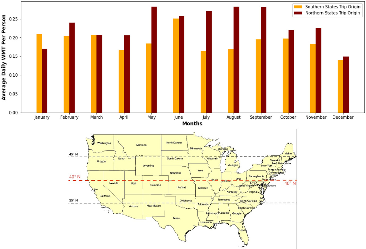
Figure 2.Average WMT per Person per Day by Month, for Northern vs Southern Trip Origins (divided by 40° latitude as shown on USA map)
StataCorp (2015) software was used to estimate respondents’ WMT values (daily versus nighttime only). Given the high number of zero-distance observations (85% of respondents made no walk trips for the first model and 99% made no nighttime walk trips), hurdle regression models are very appropriate, to reflect both the discrete decision to walk and then the continuous distance decision, simultaneously, thanks to a two-part specification. So, a hurdle specification splits the dependent variable into two parts (Cragg 1971): the logistic probability of a respondent not walking at all (and not walking at all at night) on the survey day and an exponential density function for all positive WMT (and positive nighttime WMT) possibilities. A key measure of each explanatory variable’s practical impact is shown for both models. Practical significance was obtained by increasing each covariate’s value in the large datasets (one covariate at a time) by 1 standard deviation (SD), and then taking the ratio of average WMT predictions after vs before the increase. The resulting values show the sample-average percent change in predicted WMT (from each 1 SD increase).
3. FINDINGS
Table 2 provides parameter estimates for the WMT/person/day model, with all covariates highly statistically significant, thanks in part to the large sample size. Of greater interest is which covariates have the most impact on walking, and thus are most practically significant. Workers, those without college degrees, Caucasians, older persons, and those in higher-income households are less likely to walk on their survey day. Education level is practically very significant. Increasing the Bachelor’s and Graduate degree indicator variables by 1 SD increases daily WMT predictions by +37.6% and +49.16% (per respondent), respectively. Increasing the Age variable by 1 SD decreases WMT predictions per day by almost 40%. Location is also practically very significant. Interestingly, a person’s resident state, where most of their walk trips occur, is practically very significant for some states. Georgia, California, South Carolina, Wisconsin, and Texas residents walk -32.9%, -35.1%, -39.0%, -51.6 and -58.5% fewer miles per day following a 1 SD increase in indicator variables for those respective resident states. A 1 SD increase in indicator for trips originating at longitudes between -85º and -125 º (central US) raises average WMT by ~30% per day per person, while keeping all other variables constant. A 1 SD increase in daylight’s duration comes with 22.7% more walking per day (per person).
Table 2.Model Estimates for WMT Per Person Per Day Using 2016/17 NHTS Data
| Logistic Selection Model for Pr(WMT > 0) |
|
Coef. |
T-stat |
P-value |
Pract. Sign. |
| Constant |
-0.8339 |
-30.100 |
0.000 |
|
| Age/10 |
-0.0297 |
-6.700 |
0.000 |
* |
| Worker |
-0.1290 |
-7.520 |
0.000 |
* |
| Household Income/10,000 |
-0.0060 |
-4.370 |
0.000 |
* |
| White |
Base Race |
| African American |
0.0982 |
3.770 |
0.000 |
* |
| Asian |
0.1413 |
4.730 |
0.000 |
* |
| Other Race |
0.0554 |
2.160 |
0.030 |
* |
| No High School or College Degree |
Base Degree |
| High School Graduate |
-0.1506 |
-5.590 |
0.000 |
* |
| Some Degree |
-0.0631 |
-2.500 |
0.012 |
* |
| Bachelor's Degree |
0.2213 |
8.810 |
0.000 |
* |
| Graduate Degree |
0.3702 |
13.900 |
0.000 |
* |
| Exponential Regression Model (for positive WMT values) |
|
Coef. |
T-stat |
P-value |
Pract. Sign. |
| Constant |
-0.5519 |
-2.430 |
0.015 |
|
| Age/10 |
-0.1860 |
-19.450 |
0.000 |
-39.52% |
| Male |
0.1911 |
6.140 |
0.000 |
10.01% |
| Worker |
-0.1343 |
-3.600 |
0.000 |
-14.91% |
| Household Income/10,000 |
-0.0204 |
-7.360 |
0.000 |
-15.09% |
| Length of Daylight |
0.1149 |
6.720 |
0.000 |
22.71% |
| White |
Base Race |
| African American |
0.5379 |
9.590 |
0.000 |
19.55% |
| Asian |
0.3520 |
6.010 |
0.000 |
12.46% |
| Other Race |
0.3755 |
6.470 |
0.000 |
11.95% |
| No High School or College Degree |
Base Degree |
| High School Graduate |
0.5544 |
8.840 |
0.000 |
13.39% |
| Some Degree |
0.4200 |
7.150 |
0.000 |
15.40% |
| Bachelor's Degree |
0.4614 |
8.050 |
0.000 |
37.63% |
| Graduate Degree |
0.4992 |
8.600 |
0.000 |
49.16% |
| Summer |
-0.8873 |
-2.540 |
0.011 |
-7.02% |
| Winter |
0.9572 |
1.730 |
0.084 |
6.69% |
| Spring |
-0.4114 |
-1.080 |
0.282 |
2.13% |
| Fall |
Base Season |
| Hawaii Trip Origin [<25º Latitude] |
0.1459 |
0.490 |
0.622 |
2.84% |
| 25º - 30º Latitude Trip Origin |
0.2593 |
1.000 |
0.318 |
23.21% |
| 30º - 35º Latitude Trip Origin |
0.3528 |
1.520 |
0.129 |
28.43% |
| 35º - 40º Latitude Trip Origin |
0.2719 |
1.310 |
0.190 |
16.94% |
| 40º - 45º Latitude Trip Origin |
0.1075 |
0.520 |
0.605 |
14.04% |
| 45º - 50º Latitude Trip Origin |
0.0276 |
0.110 |
0.913 |
2.35% |
| Alaska Trip Origin [>50º Latitude] |
Base Latitude Trip Origin |
| Summer * (Hawaii Trip Origin [<25º Latitude]) |
1.8075 |
3.530 |
0.000 |
NA |
| Summer * (25º - 30º Latitude Trip Origin) |
0.9155 |
2.310 |
0.021 |
NA |
| Summer * (30º - 35º Latitude Trip Origin) |
0.7916 |
2.320 |
0.020 |
NA |
| Summer * (35º - 40º Latitude Trip Origin) |
0.6373 |
1.870 |
0.062 |
NA |
| Summer * (40º - 45º Latitude Trip Origin) |
0.6928 |
2.060 |
0.039 |
NA |
| Summer * (45º - 50º Latitude Trip Origin) |
0.6003 |
1.630 |
0.104 |
NA |
| Winter * (Hawaii Trip Origin [<25º Latitude]) |
-0.9772 |
-1.580 |
0.114 |
NA |
| Winter * (25º - 30º Latitude Trip Origin) |
-0.4128 |
-0.700 |
0.481 |
NA |
| Winter * (30º - 35º Latitude Trip Origin) |
-0.8540 |
-1.530 |
0.126 |
NA |
| Winter * (35º - 40º Latitude Trip Origin) |
-0.9692 |
-1.730 |
0.084 |
NA |
| Winter * (40º - 45º Latitude Trip Origin) |
-0.7865 |
-1.410 |
0.158 |
NA |
| Winter * (45º - 50º Latitude Trip Origin) |
-0.7420 |
-1.300 |
0.195 |
NA |
| Spring * (Hawaii Trip Origin [<25º Latitude]) |
0.4923 |
0.740 |
0.461 |
NA |
| Spring * (25º - 30º Latitude Trip Origin) |
1.0878 |
2.670 |
0.008 |
NA |
| Spring * (30º - 35º Latitude Trip Origin) |
0.3702 |
0.970 |
0.332 |
NA |
| Spring * (35º - 40º Latitude Trip Origin) |
0.3862 |
1.000 |
0.315 |
NA |
| Spring * (40º - 45º Latitude Trip Origin) |
0.4163 |
1.090 |
0.277 |
NA |
| Spring * (45º - 50º Latitude Trip Origin) |
0.5187 |
1.260 |
0.207 |
NA |
| Central U.S Trip Origin (-125º to -85º Longitude) |
0.5313 |
6.820 |
0.000 |
30.31% |
| East Coast Trip Origin (-85º< Longitude) |
0.2093 |
2.060 |
0.040 |
10.74% |
| West Coast Trip Origin (-125º> Longitude) |
Base Longitude Trip Origin |
| Arizona Resident |
-0.7810 |
-6.080 |
0.000 |
-10.82% |
| Arkansas Resident |
0.6792 |
2.520 |
0.012 |
2.67% |
| California Resident |
-1.0747 |
-11.940 |
0.000 |
-35.07% |
| Colorado Resident |
0.4337 |
3.090 |
0.002 |
2.64% |
| Connecticut Resident |
0.9047 |
3.900 |
0.000 |
3.89% |
| Florida Resident |
0.5980 |
4.380 |
0.000 |
6.27% |
| Georgia Resident |
-1.5941 |
-14.700 |
0.000 |
-32.87% |
| Illinois Resident |
0.4847 |
4.740 |
0.000 |
4.30% |
| Kansas Resident |
0.4184 |
2.310 |
0.021 |
1.95% |
| Kentucky Resident |
1.0610 |
5.130 |
0.000 |
5.38% |
| Louisiana Resident |
0.3850 |
1.780 |
0.075 |
1.61% |
| Maine Resident |
0.4268 |
2.020 |
0.044 |
2.15% |
| Massachusetts Resident |
1.1644 |
9.180 |
0.000 |
7.41% |
| Michigan Resident |
0.4716 |
3.160 |
0.002 |
3.70% |
| Minnesota Resident |
0.3378 |
2.500 |
0.012 |
2.35% |
| Montana Resident |
-0.7429 |
-2.920 |
0.004 |
-3.62% |
| Nevada Resident |
0.7839 |
3.960 |
0.000 |
3.12% |
| New Jersey Resident |
1.3097 |
11.570 |
0.000 |
9.10% |
| New York Resident |
-0.2780 |
-3.100 |
0.002 |
-8.93% |
| North Carolina Resident |
-1.4188 |
-17.020 |
0.000 |
-29.78% |
| North Dakota Resident |
-0.9812 |
-3.750 |
0.000 |
-4.46% |
| Ohio Resident |
0.7295 |
5.100 |
0.000 |
6.61% |
| Oregon Resident |
0.7911 |
4.660 |
0.000 |
4.46% |
| Pennsylvania Resident |
0.9102 |
7.740 |
0.000 |
8.41% |
| Rhode Island Resident |
0.7199 |
2.070 |
0.038 |
3.03% |
| South Carolina Resident |
-2.2121 |
-19.630 |
0.000 |
-38.98% |
| South Dakota Resident |
-0.9531 |
-4.300 |
0.000 |
-4.54% |
| Tennessee Resident |
0.6282 |
3.120 |
0.002 |
3.79% |
| Texas Resident |
-2.2173 |
-23.080 |
0.000 |
-58.47% |
| Vermont Resident |
-0.6759 |
-4.030 |
0.000 |
-3.54% |
| Virginia Resident |
0.4695 |
3.460 |
0.001 |
3.50% |
| Washington Resident |
0.8988 |
5.040 |
0.000 |
6.49% |
| Wisconsin Resident |
-2.5557 |
-33.770 |
0.000 |
-51.61% |
| Residents from Remaining 27 states + Wash. D.C |
Base State of Residence |
| Final log-likelihood |
2.46E+07 |
| Pseudo R-square |
0.0568 |
| Number of observations |
254,295 |
* Asterisked variables carry the practical significance values shown in the exponential regression model.
N/A’s are shown with interaction terms, since each variable’s overall impact is shown in that variable’s earlier row.
All covariates with a p-value less than 0.10 were removed.
Table 3 provides parameter estimates for the Nighttime WMT model, along with measures of practical significance. There is a higher chance of making a nighttime walk trip on the survey day if the person has a college degree, is male, African American, worker and/or of lower household income. The second exponential regression estimating those nighttime walk distances indicate similar trends as the previous model. A 1 SD increase in indicator variables for Bachelor’s and Graduate degrees corresponds to a +36.6% and 46.6% increase in miles walked per day per person, respectively. Similarly, increasing Texas and Wisconsin resident indicator by 1 SD decreases daily WMT predictions by -47.0% and -53.6% (per respondent), respectively. A 1 SD increase in indicator for trips originating in the central U.S (between -125º and -85º longitude) raises average WMT per person per day by +31.4%.
Table 3.Model Estimates for WMT Per Person Per Day at “Night” using 2016/17 NHTS Data
| Logistic Selection Model for Pr(Nighttime WMT > 0) |
|
Coef. |
T-stat |
P-value |
Pract. Sign. |
| Constant |
-2.316 |
-46.500 |
0.000 |
|
| Male |
0.076 |
2.490 |
0.013 |
* |
| Worker |
0.112 |
3.280 |
0.001 |
14.65% |
| Household Income/10,000 |
-0.011 |
-3.720 |
0.000 |
* |
| All Other Races |
Base Race |
| African American |
0.091 |
1.760 |
0.079 |
* |
| No College Degree |
Base Degree |
| Bachelor's Degree |
0.177 |
3.770 |
0.000 |
* |
| Graduate Degree |
0.269 |
5.970 |
0.000 |
* |
| Exponential Regression Model |
|
Coef. |
T-stat |
P-value |
Pract. Sign. |
| Constant |
0.753 |
1.300 |
0.194 |
|
| Age/10 |
-0.106 |
-3.350 |
0.001 |
-20.63% |
| Male |
0.241 |
2.900 |
0.004 |
24.08% |
| Household Income/10,000 |
-0.021 |
-2.480 |
0.013 |
-23.97% |
| All Other Races |
Base Race |
| African American |
0.577 |
5.720 |
0.000 |
23.48% |
| Asian |
0.552 |
2.670 |
0.008 |
8.17% |
| No High School or College Degree |
Base Degree |
| High School Graduate |
0.528 |
2.650 |
0.008 |
19.12% |
| Some Degree |
0.466 |
2.360 |
0.018 |
27.96% |
| Bachelor's Degree |
0.324 |
1.690 |
0.092 |
36.61% |
| Graduate Degree |
0.321 |
1.680 |
0.093 |
46.62% |
| Spring |
0.353 |
2.840 |
0.005 |
15.29% |
| All Other Seasons |
Base Season |
| 45º - 50º Latitude Trip Origin |
-1.323 |
-1.920 |
0.055 |
-17.79% |
| Remaining Latitude Trip Origin [>50º Latitude <45º] |
Base Latitude Trip Origin |
| Central U.S Trip Origin (-125º to -85º Longitude) |
0.548 |
2.620 |
0.009 |
31.43% |
| East & West Coast Trip Origin (-125º> Longitude>-85º) |
Base Longitude Trip Origin |
| California Resident |
-0.833 |
-5.100 |
0.000 |
-28.44% |
| Connecticut Resident |
1.826 |
4.380 |
0.000 |
8.01% |
| Florida Resident |
1.336 |
4.390 |
0.000 |
14.55% |
| Georgia Resident |
-1.155 |
-5.320 |
0.000 |
-25.08% |
| Hawaii Resident |
0.702 |
2.490 |
0.013 |
3.33% |
| Illinois Resident |
1.040 |
3.120 |
0.002 |
9.45% |
| Kentucky Resident |
1.517 |
5.450 |
0.000 |
7.78% |
| Louisiana Resident |
1.832 |
6.600 |
0.000 |
7.90% |
| Maryland Resident |
0.676 |
2.840 |
0.004 |
7.41% |
| Massachusetts Resident |
2.136 |
14.050 |
0.000 |
14.02% |
| Michigan Resident |
0.992 |
2.140 |
0.033 |
7.94% |
| New Jersey Resident |
1.368 |
6.080 |
0.000 |
9.52% |
| New Mexico Resident |
2.008 |
4.520 |
0.000 |
8.70% |
| North Carolina Resident |
-0.912 |
-3.900 |
0.000 |
-20.32% |
| Ohio Resident |
1.819 |
4.770 |
0.000 |
17.29% |
| Oregon Resident |
1.433 |
2.980 |
0.003 |
8.22% |
| Pennsylvania Resident |
1.797 |
4.580 |
0.000 |
17.29% |
| Rhode Island Resident |
1.102 |
1.730 |
0.083 |
4.68% |
| South Carolina Resident |
-1.552 |
-6.260 |
0.000 |
-29.29% |
| Tennessee Resident |
1.563 |
6.830 |
0.000 |
9.69% |
| Texas Resident |
-1.938 |
-11.300 |
0.000 |
-53.61% |
| Virginia Resident |
1.117 |
4.040 |
0.000 |
8.53% |
| Washington Resident |
1.423 |
3.010 |
0.003 |
10.47% |
| Wisconsin Resident |
-2.234 |
-12.790 |
0.000 |
-46.99% |
| Wyoming Resident |
-1.598 |
-2.550 |
0.011 |
-6.99% |
| Residents from Remaining 25 states + Wash. D.C |
Base State of Residence |
| Final log-likelihood |
-2.71E+07 |
| Pseudo R-square |
0.0495 |
| Number of observations |
254,295 |
* Asterisked variables have their practical significance values shown in the exponential regression model for the same variable.
All covariates with a p-value less than 0.10 were removed.
Results show how race, education, age and income have practically significant effects on walk-mode and walk-distance choices in this large dataset. Resident states and longitudes (locations) have major impacts, with residents from southern states walking shorter distances (even at night). Length of daylight also has practically significant effects on walk distances. Intriguingly, Americans in southern US locations (which enjoy more sunshine/better lighting and warm weather) do not walk as much, and face higher pedestrian crash risk per mile walked. Dividing pedestrian fatalities (averaging 2014-2019 counts [FHWA, 2017; NHTSA, 2022]) by WMT extrapolations for each state’s resident population (and visitors, which are key in Washington DC’s and Delaware’s cases) places all southern states among the nation’s 10 most deadly, as shown in Figure 3, with Alabama and Mississippi topping the list. As noted earlier, southern states lead in terms of pedestrian crash rates per VMT (NHTSA, 2022). Southern states like Mississippi, New Mexico, South Carolina, Florida, Louisiana, and Arizona rank among the top 10 states with both the highest pedestrian fatalities per WMT and overall traffic fatalities per VMT. Lack of enforcement, poor design, weaker licensing laws, and driver culture may need to be examined as potential causes for many of these southern states.
_across_us_states.png)
Figure 3.Rankings of Pedestrian Deaths per Walk-Mile Traveled (WMT) across US States
ACKNOWLEDGEMENTS
The authors thank Jade (Maizy), Jeong, Aditi Bhaskar, and Balasubramanian Sambasivam for their editing (and administrative) support.
Submitted: March 31, 2023 AEST
Accepted: October 28, 2023 AEST