1. Questions
Advanced Aerial Mobility (AAM) is an inclusive term that covers urban, regional, intraregional, and suburban air mobility solutions. AAM vehicles can be used for on-demand air mobility, cargo and package delivery, healthcare applications, and emergency services (Goyal et al. 2021), which would all have different levels of usability with various vehicles in different climates, populations, and geographies. Large companies like Airbus and Joby Aviation are starting to explore Urban Aerial Mobility (UAM) passenger-transport operations (Gomez 2021), and Amazon and Alphabet-owned Wing have been using drones for beyond-visual-line-of-sight package delivery on a limited basis for several years (Palmer 2020). The United States National Academies of Science, Engineering, and Medicine developed a National Blueprint for Advanced Aerial Mobility in 2020 (NASEM 2020), and AAM operations may enable energy and environmental benefits when transporting small cargo (Rodrigues et al. 2022) and passengers (Kasliwal et al. 2019).
Specific local weather conditions such as temperature, wind, visibility, and sky conditions could prevent AAM vehicles from flying. We develop a method to quantify and analyze the potential number of flyable hours for an AAM vehicle in various regions of the United States. This analysis also informs possible causes that lead to loss of flyable flight hours in various regions.
Our research questions investigating the feasibility of AAM operations are: Which are the geographical areas in the continental United States that enable the most flyable hours over a year? What is the leading cause of non-flyable hours?
2. Methods
We use Meteorological Aerodrome Reports (METARs) from the National Oceanic and Atmospheric Administration for 91 U.S. airports. The Iowa State University Mesonet tool (Herzmann, Arritt, and Todey 2022) provides code that parses and outputs current METAR data from any location (NOAA 2021). We used this tool as a reference to decode current METAR data to use in our analysis. We parse the METARs into 5-minute intervals and output whether that time slot has conditions that are acceptable for flight, which are outlined in Table 1. The specifications used are from Class E Visual Flight Rules guidelines from the U.S. Federal Aviation Administration (FAA) for below 10,000 feet Mean Seal Level (MSL). Assuming an electric AAM vehicle, we use the specifications of a standard drone with Lithium-Polymer batteries which restricts ambient flight temperatures to be between -10°C and 40°C. The wind specifications come from the Cirrus SR22, which is a proxy for a proposed AAM vehicles. The same process can be carried out using the specifications for any aircraft and energy storage system, which have a range of operational specifications. We provide our code in an online repository (Sharma 2021). Gaps in the METAR data set, which represent a very small number of total data, are filled using the previous time stamp.
We conducted our analysis on 91 airports across the contiguous United States. The subset of airports includes all airports with Class B airspace and Class C airspace. To ensure consistent spatial coverage over the country, some airports with Class D and E airspace were also included. There are fewer than approximately 300 miles between any two airports within the subset. Although METAR data is only accurate for the airspace, we generalize the results of these data to the surrounding counties as a means of showing larger trends across the country. Our method can be applied specifically to METARs collected at local weather stations in order to obtain more precise results at specific locations.
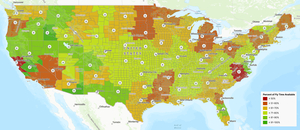
After running through the parsing program, we import the data on the number of flyable 5-minute slots and the number of slots made non-flyable by each weather attribute into GIS to create visualizations of the results in Figure 1 and Figure 3, respectively.
3. Findings
As Figure 1 shows, there is nearly double the annual acceptable flying time between the most flyable and least flyable locations in the country. The Midwest experiences extremely cold weather, which explains the lowest percentage of fly-time in that region. In contrast, the percent of flyable hours increases to almost 100% in the Southwestern states and closer to the West coast, where the weather is much warmer and relatively mild in terms of wind speeds and sky conditions that affect visibility. The map also highlights the micro-climate in California’s Bay Area—this area is much windier than the rest of the state, accounting for the lower percentage of flyable hours.
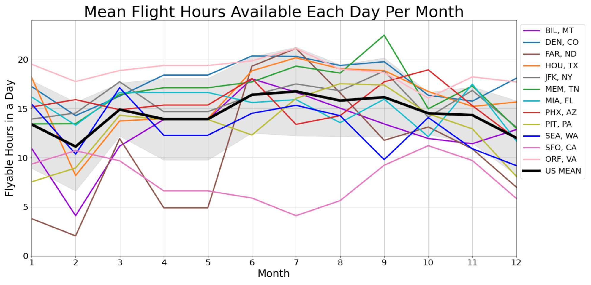
To investigate the seasonal impacts on flyable hours in different regions, we first chose 12 airports within the 18 different types of climates (comprised of six zones with three sub categories each) detailed by the Office of Energy Efficiency and Renewable Energy (USDOE 2013). As shown in Figure 2, there is large variance amongst the average flying hours available across the country in different climates. The seasonal cycle has much more of an effect on the airports in the north (cool humid), such as PIT and JFK, whereas SFO experiences the same micro-climate year round (warm marine) and has lower flight time available consistently.
All over the contiguous United States, cloud cover at heights lower than 3000 feet (914.4 meters) AGL is the biggest contributor to making times non-flyable for AAM vehicles. Since this is consistent across all airports, Figure 3 highlights the second-most discounted reason for each airport. We can see that along the coasts, there can be winds speeds that are too high to fly in. The Midwest can have times too cold to fly, and the visibility in the South tends can be too low.
Overall, the central areas of the United States (farther from coasts) tend to have more annual flyable AAM hours under our assumptions. Our analysis shows nearly double the amount of annual acceptable flying time between the most flyable and least flyable locations in the country and identifies the largest cause of non-flyable hours as cloud cover. Our method can be provide a high-level understanding of the viability of AAM vehicles in a geographic location, and can be used to explore other technical assumptions about AAM capabilities in future work.
Acknowledgements
This research was partially supported by the National Science Foundation (NSF Collaborative Award Number CMMI 1635638/1635686/1742858), the U.S. Department of Energy’s Vehicle Technologies Office, Award Number DE-EE0008463, and the Department of Civil and Environmental Engineering Research Internship Program at Carnegie Mellon University. This material is based upon work supported by the National Science Foundation Graduate Research Fellowship under Grant No. DGE1745016. This research was initiated when C.S. was with Carnegie Mellon University. The opinions expressed in this article are the authors’ own and do not reflect the view of the United States government or any other organization.


