
1. Questions
Intercity bus may be seeing a ridership revival (Fischer and Schwieterman 2011; Klein 2015, 2009), but many downtown Greyhound bus stations have recently closed (Cidell 2026). In this paper, we employ downtown bus station closure/relocation as an empirical opportunity to explore how access to intercity bus changes under a bus station-airport merger (Kasarda 2008; Toet et al. 2022; Goetz and Vowles 2010). We operationalize this interest to:
-
Quantitatively define an accessibility metric to intercity bus services
-
Measure such accessibility using different local access modes
-
Explore changes in accessibility under station relocation.
Our measure builds on the Aviation-accessibility Integrated Mobility (AIM) metric (Karam et al. 2022). We first describe the development of a Bus + AIM metric (BAIM) and then analyze the distribution of accessibility across census tracts under different local access/station location scenarios for the Cleveland, OH area. Cleveland’s bus station recently relocated from downtown to nearby the airport (CLE-Hopkins) (Glaser 2026).
2. Methods
The AIM describes intercity accessibility between origin and destination airports across census tracts for a given metropolitan area (Karam et al. 2022). The metric incorporates impedance measures that limit intercity mobility, including flight price/availability, reliability, and cost of local transport to the airport. Impedance factors are weighted by coefficients based on sensitivities to travel costs from user surveys and tract level income. The full derivation of the AIM metric is described in Karam et al. (2022).
We take the AIM and modify it to incorporate the unique characteristics of bus, as compared to air travel. The BAIM metric is defined as:
\[BAIM_{qj} = max(M_{qijk}).\]
is an impedance function built on the following three inputs:
\[M_{qijk} = C_{ij} + A_{qik} + T_{ij}\]
where measures impedance due to intercity cost (bus fare), measures impedance due to local access (travel time, cost, and propensity to use a given local access mode), and measures impedance due to intercity travel time and reliability. The derivation of each of these metrics follows those described in Karam et al. (2022). Indexes are: residential census tract; bus station location at the origin; final destination; and local access mode (car, transit, bicycle, etc.).
The BAIM is flexible to incorporate multiple origins, destinations and access modes. Here, we explore one case study of travel between Cuyahoga County (Cleveland area), and Chicago, IL, We measure variation in the BAIM with local access mode, and station relocation, for downtown to the airport area location.
Each impedance measure is scaled by sensitivity coefficients discussed in detail in the supplemental information to this paper and in Tables 1 and 2 in Karam et al. (2022). We use the sensitivity coefficients from Karam et al. (2022) without modifications to the intercity bus environment, given the extremely limited knowledge around bus users sensitivities.
Our interest is primarily in the impact of local access mode on accessing intercity bus services. Therefore, in this case study we construct the BAIM absent maximization across local access modes, and instead primarily discuss the distribution of local access impedance, across access modes for transit and car, and station locations for downtown and airport area. In the supplemental information we also investigate the joint impact of area level household income, local access mode, and station location. Transit and car travel times are imputed from the census tract centroid to both station locations using the r5r package in the software R (Pereira et al. 2021; R Core Team 2026).
There are 428 census tracts in Cuyahoga County that could theoretically enter the study area. However 11 tracts do not have estimated median household income and were removed from analysis as income levels could not be defined to model impedance. In addition, 1 tract centroid did not have a valid roadway connection to the airport area or downtown locations and could not be routed for travel time and was removed. Finally, any tracts where the 75th percentile for transit travel time to either the downtown or airport area stations was greater than 120 minutes (n=102) were removed from the case study area, as these tracts either feature unreasonably long travel times or feature no transit connections. Together, these 114 tracts were removed from the final analytic data set, leaving a study area of 314 census tracts that serve as the denominator for all analyses. Our findings therefore do not pertain to the totality of Cuyahoga County. Rather, we retain a set of observations where car and transit travel are both defined in order to make comparisons across local access modes, rather than defining different denominators for each mode. All data and code used to conduct this analysis can be found at https://doi.org/10.7910/DVN/HVIFSB (Version 2).
3. Findings
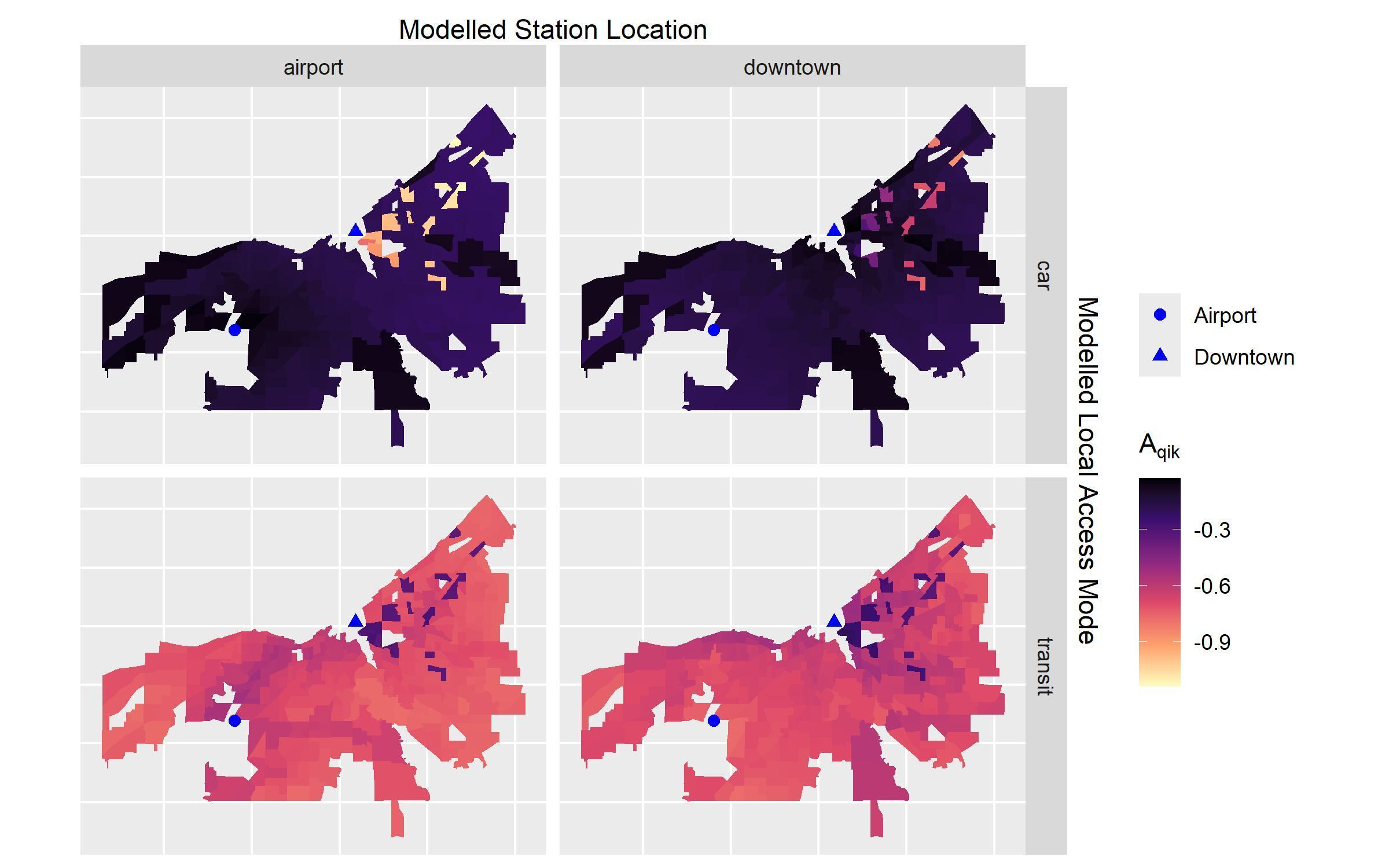
Figure 1 describes local access impedance for transit at the average level of service (50th percentile travel time) and for car to the airport area and downtown locations. Recall, that these are the impedance values for each travel mode, rather than maximizing across modes. Higher values signal greater local access to intercity bus service.
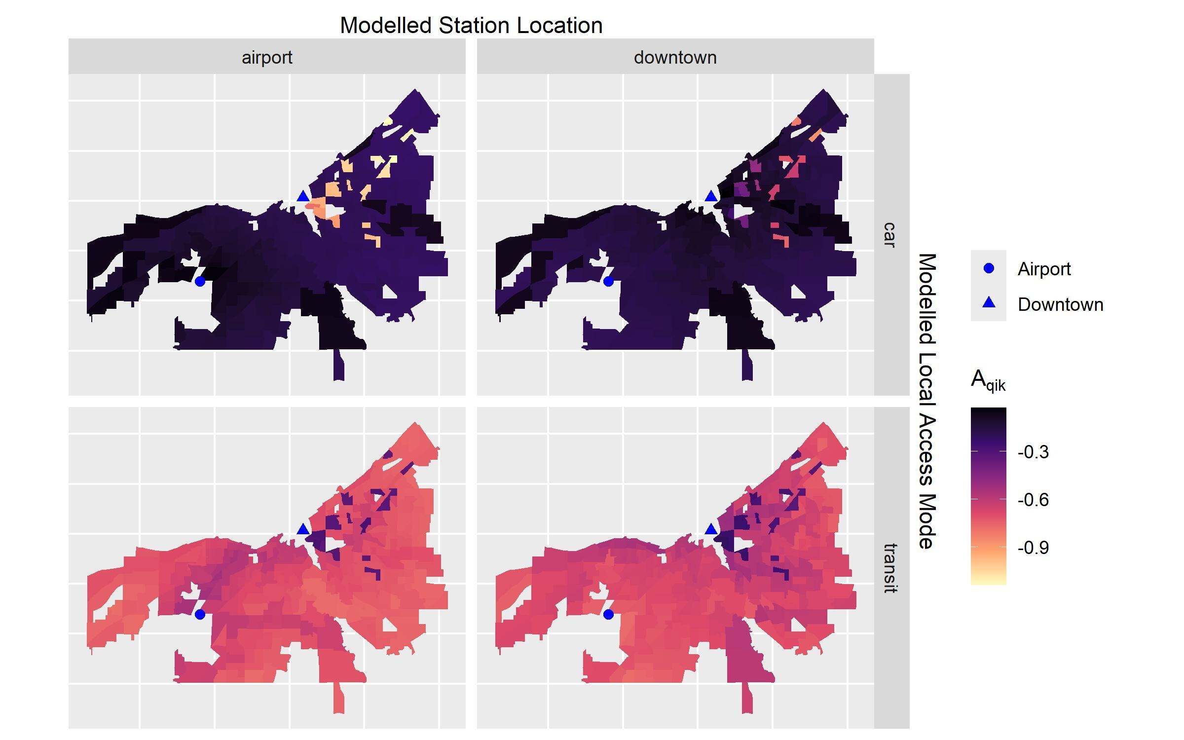
For both station locations, access by car dominates, reflecting the car-oriented transportation geography in the Cleveland area. Only 20 tracts (6%) feature higher transit than car access to the airport station location and 17 tracts (5%) feature higher transit than car access to the downtown location. The measure is also able to capture areas where station relocation yields theoretical access gains by local access mode: 70 tracts (22%) see improved transit access and 85 tracts (27%) see improved car access with station relocation to the airport. Some of this effect is driven by spatial proximity to the airport. However, the BAIM, and more specifically, accounts for tract-level income when considering the differential impedance of monetary cost in the local access environment. The more interesting cases are those isolated tracts with higher values in general areas of lower values. In these areas, the metric captures improved theoretical transit access with station relocation, due to the combined effect of efficient transit service and lower aggregate incomes in these areas (see additional discussion on these tracts in the supplemental information).
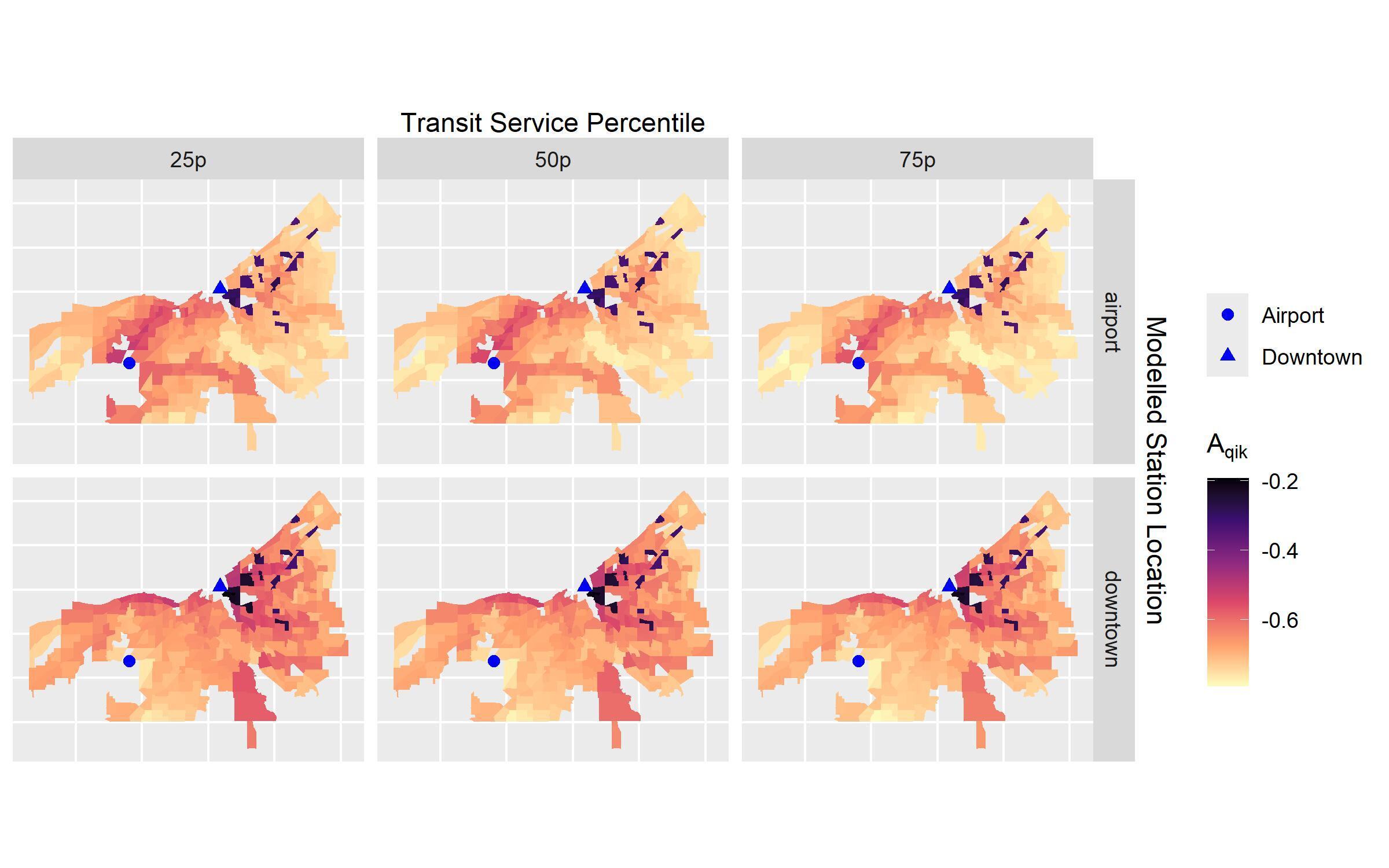
The BAIM is also able to capture changes in access based on levels of service in the local access mode. Figure 2 describes the change in values by transit travel time percentiles and station relocation. Across levels of service, access by transit theoretically decreases for the majority of census tracts following station relocation. At the most efficient service (25th percentile) only 74 tracts (24%) see increased access to the airport compared to downtown, as compared to 70 tracts (22%) at average service (50th percentile) and inefficient service (75th percentile). This is likely a product of the many bus and rail connections in downtown, nearby the former Greyhound station.
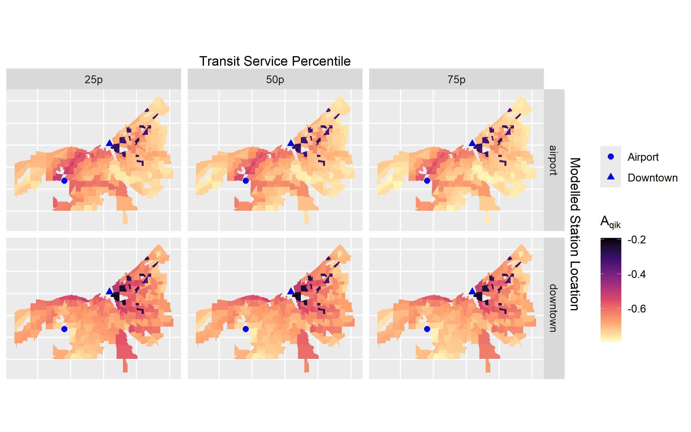
However, the distribution in values also display a pattern of spatial bifurcation where tracts closer to the airport see greater access, across travel time percentiles, to intercity bus services. Further research could explore the populations in these select tracts to better understand how relocation impacts access to intercity services for the transit-dependent.
We empirically measure the BAIM with limited knowledge on intercity bus users’ sensitivities and accessibility levels. The air-travel derived coefficients employ fixed weights based on the aviation literature, but do not reflect survey-based sensitivities from bus users. Our literature review revealed no examples that attempt to formally define intercity travel sensitivities by bus, and only select examples that surveyed intercity bus users (Klein 2015; Sperry et al. 2014). Individual-level administrative data for intercity bus is limited, meaning key variables like cost, travel time, and processing time are not routinely collected. Together, these limitations chart the important research pathway going forward - fielding intercity bus surveys that better describe sensitivities. With data parallel to air travel, future research could account for the impact of changes to the network, fares, processing time, convenience, and more. We are eager to collect such data and engage these future research directions.
Acknowledgements
The authors gratefully acknowledge the support of a Collaborative Research Agreement between the University of Pennsylvania and Oberlin College, the Ken and Joan Nelson Fund for Student Research at Oberlin College, Internal Grant Funding from Oberlin College, the Oberlin Summer Research Institute, and partial support from the National Aeronautics and Space Administration University Leadership initiative under Grant No. 80NSSC24M0068. The authors also thank Shriya Karam and Carrie S. Long for thought partnership on this work.