Loading [Contrib]/a11y/accessibility-menu.js
Skip to main content
null
Findings
  • Menu
  • Articles
    • Energy Findings
    • Resilience Findings
    • Safety Findings
    • Transport Findings
    • Urban Findings
    • All
  • For Authors
  • Editorial Board
  • About
  • Blog
  • covid-19
  • search

RSS Feed

Enter the URL below into your favorite RSS reader.

http://localhost:23905/feed
Transport Findings
December 13, 2024 AEST

Metropolitan Planning Organizations’ Uses of and Needs for Big Data

Ekin Ugurel, Xinhua Wu, Ryan Wang, Brian H. Y. Lee, Cynthia Chen,
big datatransportation planningmetropolitan planning organizationsperceptions
Copyright Logoccby-sa-4.0 • https://doi.org/10.32866/001c.127143
Findings
Ugurel, Ekin, Xinhua Wu, Ryan Wang, Brian H. Y. Lee, and Cynthia Chen. 2024. “Metropolitan Planning Organizations’ Uses of and Needs for Big Data.” Findings, December. https:/​/​doi.org/​10.32866/​001c.127143.
Save article as...▾
Download all (3)
  • Figure 1. Bar plot of answers mentioned in response to “In which area does your MPO operate?”
    Download
  • Figure 2. Word cloud of answers to "What word comes to mind when you think of “big data”? (98 responses)
    Download
  • Figure 3. Bar plot of factors mentioned in response to “What would help you gain confidence or have trust in using big data?”
    Download

Sorry, something went wrong. Please try again.

If this problem reoccurs, please contact Scholastica Support

Error message:

undefined

View more stats

Abstract

Big data products offer a new paradigm to understand and analyze human mobility patterns, a primary interest of long-range transportation planners. However, it remains unclear how widely these datasets are utilized by planners and to what extent they influence decision-making. We present the perspectives of more than 50 planners from MPOs across the United States. While we found a range of use cases, there was also a tendency to focus on a narrow set of applications. Transparency, regulation, and legitimacy emerged as the primary factors influencing adoption decisions.

1. QUESTIONS

Long-range transportation planners (LRTPs) are tasked with supporting decision-makers in shaping multibillion-dollar investments in future mobility. In recent years, the increased availability and commercialization of big data have resulted in the rise of mobility-analytics vendors who offer a suite of products, hereafter referred to as big data products (BDPs), designed to help planning agencies make more informed decisions. These vendors aggregate passively collected data from multiple sources (such as smartphones, in-vehicle GPS trackers, connected-vehicle data, etc.) to generate transportation-related products such as volume counts on a corridor or between an origin-destination pair, which can be invaluable for understanding mobility trends and planning future infrastructure investments.

While BDPs offer a new way to understand and analyze mobility patterns, we know little about their actual use in transportation planning. It is unclear how widely these datasets or products are being utilized by planners or to what extent they are influencing decision-making processes. Moreover, the full potential of these datasets, especially in areas such as forecasting, equity analysis, and resilience planning, remains largely unexplored. Understanding the gaps in usage and application is key to unlocking their value for long-term transportation planning.

Our paper is motivated by two recurring themes identified through ad-hoc conversations with various practitioners. These themes are: (A) the use of BDPs has been limited to a narrow range of applications and they are not the preferred solution to many problems faced by LRTPs; and (B) only a small number of MPOs (primarily ones with sufficient resources) use BDPs. Thus, this paper addresses the following questions:

  1. How do planners perceive big data products offered by mobility analytics companies?

  2. What factors influence an MPO’s decision to adopt big data products and services?

  3. What are the various use cases for big data in regional transportation planning?

2. METHODS

We conducted an interactive workshop at the Association of Metropolitan Planning Organizations (AMPO) Planning Tools & Training Symposium in Albuquerque, New Mexico, in May 2024. The workshop was attended by over 50 participants, all of whom held roles related to LRTPs in some capacity.

We used Mentimeter to facilitate real-time engagement and gather background information. Then, based on the answers to the question, “What best describes your role in your MPO?” (Table 1), we divided the room into three roughly even-sized groups and conducted focus group discussions tailored to each group’s role and expertise.

3. FINDINGS

Descriptive Statistics of Participants

The workshop saw participation from MPO staff from across every geographical region in the United States, with the Northeast and the Pacific Northwest (PNW) having the most participants (see Figure 1). When asked about their MPOs’ experience with BDPs, most of the participants hinted at some proficiency through in-house usage or via consultants—only 17 percent of the respondents had no prior hands-on experience with BDPs (see Table 1). The prior exposure of workshop participants suggests their insights would be more informed and valuable to the discussion.

Figure 1
Figure 1.Bar plot of answers mentioned in response to “In which area does your MPO operate?”

We also asked the respondents about their role within the MPO as shown in Table 1. They were almost evenly divided between technical staff who primarily work with data (33%), managers who primarily supervise people, projects, or consultants (23%), and staff who do both (37%). Hearing from both technical and managerial staff is crucial, as their perspectives on the use of BDPs may differ. Technical staff are typically more engaged with the practical, day-to-day data challenges, while managerial staff are more focused on broader strategic concerns such as resource allocation and decision-making processes. Both viewpoints offer complementary insights into how BDPs can be integrated into MPO operations.

Table 1.Distribution of answers to exploratory questions about the audience
Answer Percentage*
“What experience does your MPO have with big data?” None. 7%
We’re learning about it but don’t have hands-on experience. 10%
We’ve experimented with it through trial subscriptions or purchases. 17%
We’ve used it in-house or through consultants to support work programs or planning/policy decisions. 66%
“What best describes your role in your MPO?” I primarily manage people, projects, or consultants; focus on the big picture; and do NOT handle data. 23%
I primarily work with data to support my MPO’s work programs and projects 33%
I perform some management, consider the big picture, AND directly process/analyze data 37%
I perform other roles that little to do with data. 7%

*rounded to nearest integer

To minimize ambiguity and avoid influencing planners’ responses, we explicitly defined big data as “data collected from ubiquitous mobile devices (e.g., smartphones and in-vehicle GPS trackers) that was not originally intended for transportation planning purposes.” We note that the goal of the workshop was not to achieve a statistically representative sample of MPOs, but rather to gather a diverse range of perspectives from planning professionals across different regions.

Perceptions of Big Data Products

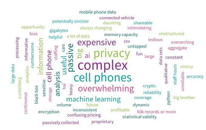
Most planners view big data as complementary to traditional data collection methods—neither a complete replacement nor without value. During the focus group discussions, we found some differences in how managers perceived BDPs compared to that of technical MPO staff. Managers perceived big data as a tool for updating functional classification of various roadways and doing related analyses, such as deriving mode splits, normalizing crash rates, and assessing land use impacts and project effectiveness. In contrast, technical staff highlighted the role of BDPs in data validation and completion, serving as proxies for incomplete datasets and validating travel demand models. Figure 2 illustrates the most common associations planners have with big data. Adjectives such as complex, overwhelming, and expensive were frequently mentioned, along with nouns like cell phones, privacy, AI, machine learning, and passive data.

Figure 2
Figure 2.Word cloud of answers to "What word comes to mind when you think of “big data”? (98 responses)

Factors Influencing MPO Adoption

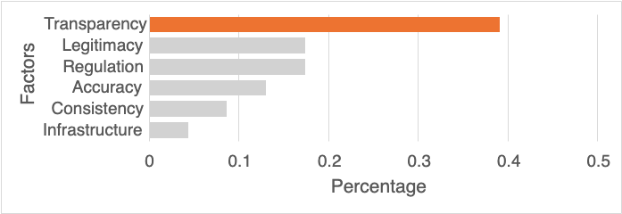
When asked, “What would help you gain confidence or have trust in using big data?”, transparency stood out as the most significant factor influencing planning organizations’ adoption of big data, as participants emphasized the need for clear information on how data is collected, processed, and validated (see Figure 3). Legitimacy was the second most common concern, involving the ability to assess BDP quality via reviews, proven experiences, and academic studies (thereby reducing risk). Regulation ranked third, referring to data quality guidance from transportation authorities and decision makers with vested interest.

Figure 3
Figure 3.Bar plot of factors mentioned in response to “What would help you gain confidence or have trust in using big data?”

As a follow-up, we asked participants what they would like to know about BDPs that they do not already know. The responses included questions regarding the quality of the data like “How accurate is it?” and “Is the accuracy consistent over time?”, questions that expand on transparency from the supplier side like “What steps were taken between the raw and processed datasets?”, as well as operational-level questions about the process of adopting BDPs like “Will costs change over time?” and “How do we ‘keep’ the data we buy after our contract ends?”. These cost-related questions highlight the need for greater transparency in pricing structures and clearer terms of use to help MPOs make informed investment decisions. Exploring sustainable funding mechanisms could also alleviate cost-related challenges (i.e., for smaller MPOs) and promote broader adoption of BDPs.

Interestingly, the questions that piqued the interest of managerial MPO staff were not perfectly aligned with those of more technical backgrounds. LRTPs who processed or were otherwise hands-on with big data products brought up more concepts related to methodology and data application than the managers. For example, the idea to standardize preprocessing algorithms were popular among planners who have worked with the data, as well as questions relating to the extent that trip chaining, a travel behavior concept, can be captured in the data. On the other hand, managerial staff concerns tended more toward the cost, consistency, and reliability of big data products. These differences highlight how varied professional roles within MPOs influence priorities and concerns, suggesting that BDP adoption strategies may need to be tailored to address the distinct needs of technical and managerial staff.

Use Cases

We found a wide range of BDP use cases among MPOs, as detailed in Table 2. However, the majority of LRTPs focus on a small number of BDP applications. The most frequently mentioned benefits of partnering with mobility-analytics companies were the ability to easily derive peak traffic volumes for low functional classification roads, understand turn counts at intersections, and measure pedestrian and cyclist activity. This seemed to agree with our hypothesis that many MPOs who adopt BDPs only utilize them for a narrow scope of problems.

Table 2.Types of questions MPO staffers have solved or plan on solving, categorized
Category Short Description Long Description
Equity-related Quantifying work-housing imbalance and job accessibility (Zhou, Yeh, and Yue 2018; Zhang, Zhou, and Zhang 2017) Analyzing the distribution of jobs relative to housing to ensure equitable access to employment opportunities.
Identifying locations of high noise and vehicle emissions on highway network (Lan, He, and Cai 2020) Locating areas with high levels of noise and emissions to address environmental justice concerns.
Assessing community resiliency (Sarker et al. 2020) Assessing the transportation network’s ability to withstand and recover from adverse events such as natural disasters.
Planning-related Origin-destination studies (Alexander et al. 2015; Iqbal et al. 2014; Z. Liu, Liu, and Fu 2022) Studying travel patterns between different origins and destinations to understand mobility flows.
Mode choice analysis (Phithakkitnukoon et al. 2017; Gong et al. 2012; M. Yang et al. 2022) Analyzing the factors influencing the selection of different modes of transport (e.g., car, public transit, cycling).
Complete Street studies (“Lessons Learned from Evaluating Complete Streets Project Outcomes with Emerging Data Sources,” n.d.) Planning and designing streets that accommodate all users, including pedestrians, cyclists, and motorists.
Visitor analysis (Miah et al. 2017; Reif and Schmücker 2020) Understanding the travel behaviors and patterns of visitors to optimize transportation services for tourism.
Validation of observed travel behavior data (Chen et al. 2016; F. Liu et al. 2014; Ugurel, Huang, and Chen 2024) Comparing big data insights with observed travel behaviors to ensure accuracy and reliability.
EV charging demand estimation (T. Yang et al. 2017) Forecasting the demand for electric vehicle charging stations to support the growing number of EVs.
Transit planning and routing (Lu et al. 2021; Hadjidimitriou, Lippi, and Mamei 2021) Designing and optimizing public transit routes to improve efficiency and coverage.
Bicycle and pedestrian trip planning (Lee and Sener 2020; Yu et al. 2020) Tracking bicycle and pedestrian trips to support infrastructure improvements and promote active transportation.
Freight movement tracking (Akter, Hernandez, and Camargo 2023) Monitoring the movement of goods to enhance freight logistics and reduce congestion.
Land use changes (Yin et al. 2021) Assessing the impact of land use changes on transportation networks and planning accordingly.
Safety-related Safety planning and project identification (Ambros et al. 2024) Identifying and prioritizing safety projects to reduce accidents and enhance road safety.
Crash hotspot analysis (Xie et al. 2017) Pinpointing locations with high accident rates to implement targeted safety measures.
Mobile device usage while driving (Khurana and Goel 2020; Ahlström et al. 2020) Monitoring mobile device usage to identify distracted driving behaviors and develop interventions.
Lane change analysis (Park et al. 2018) Analyzing lane change behaviors to improve road design and traffic flow management.
Operational-related Land border crossing monitoring (Sakhare et al. 2024) Providing real-time information on wait times and traffic conditions at land border crossings.
Through trip volume estimation (Huntsinger and Ward 2015) Measuring the volume of trips passing through a region without stopping to better understand transit patterns.
Turn count estimation (Kan et al. 2019) Counting vehicle turns at intersections to optimize signal timing and improve traffic flow.
Demand estimation during special events (Pereira, Rodrigues, and Ben-Akiva 2015) Analyzing transportation demand and patterns during special events to enhance planning and resource allocation.

Among the use cases shown in Table 2, we found few prior works on using big data to study work-housing imbalances and job accessibility (i.e., only in the context of cities in China). Other equity-related applications, such as identifying locations of high noise and vehicle emissions on highway networks and assessing community resiliency, were similarly under-explored. Such literature often exists in the form of reports or case studies fiscally sponsored by planning authorities. More connection between academic and public-sector research in these areas could provide valuable insights to address transportation inequities and improve public health and community resilience.

Conclusion

While big data presents promising tools for advancing transportation planning, its adoption faces challenges due to concerns over transparency, legitimacy, and regulation. Planners’ perceptions of big data differ based on their managerial or technical roles. Moreover, most focus on a limited set of applications despite the broader range of potential use cases. To fully realize the potential of big data in transportation planning, stakeholders must prioritize developing clear regulatory frameworks, fostering collaboration between data providers and planners, and investing in capacity-building efforts that bridge the gap between technical and managerial perspectives. This requires coordinated action from policymakers, industry leaders, and planning organizations to ensure equitable, transparent, and effective integration of big data into planning processes.

Submitted: October 22, 2024 AEST

Accepted: December 09, 2024 AEST

References

Ahlström, C., J. Wachtmeister, M. Nyman, A. Nordenström, and K. Kircher. 2020. “Using Smartphone Logging to Gain Insight about Phone Use in Traffic.” Cogn Tech Work 22 (1): 181–91. https:/​/​doi.org/​10.1007/​s10111-019-00547-6.
Google Scholar
Akter, T., S. Hernandez, and P. V. Camargo. 2023. “Freight Operational Characteristics Mined from Anonymous Mobile Sensor Data.” Transportation Research Record 2677 (9): 236–47. https:/​/​doi.org/​10.1177/​03611981231158639.
Google Scholar
Alexander, L., S. Jiang, M. Murga, and M. C. González. 2015. “Origin–Destination Trips by Purpose and Time of Day Inferred from Mobile Phone Data.” Transportation Research Part C: Emerging Technologies 58 (September):240–50. https:/​/​doi.org/​10.1016/​j.trc.2015.02.018.
Google Scholar
Ambros, J., J. Elgner, V. Valentova, R. Bak, and M. Kiec. 2024. “Proactive Safety Assessment of Urban Through-Roads Based on GPS Data.” Archives of Transport 69 (1). https:/​/​doi.org/​10.61089/​aot2024.gpa7v104.
Google Scholar
Chen, C., J. Ma, Y. Susilo, Y. Liu, and M. Wang. 2016. “The Promises of Big Data and Small Data for Travel Behavior (Aka Human Mobility) Analysis.” Transportation Research Part C: Emerging Technologies 68 (July):285–99. https:/​/​doi.org/​10.1016/​j.trc.2016.04.005.
Google Scholar
Gong, H., C. Chen, E. Bialostozky, and C. T. Lawson. 2012. “A GPS/GIS Method for Travel Mode Detection in New York City.” Computers, Environment and Urban Systems 36 (2): 131–39. https:/​/​doi.org/​10.1016/​j.compenvurbsys.2011.05.003.
Google Scholar
Hadjidimitriou, N. S., M. Lippi, and M. Mamei. 2021. “A Data Driven Approach to Match Demand and Supply for Public Transport Planning.” IEEE Transactions on Intelligent Transportation Systems 22 (10): 6384–94. https:/​/​doi.org/​10.1109/​TITS.2020.2991834.
Google Scholar
Huntsinger, L. F., and K. Ward. 2015. “Using Mobile Phone Location Data to Develop External Trip Models.” Transportation Research Record 2499 (1): 25–32. https:/​/​doi.org/​10.3141/​2499-04.
Google Scholar
Iqbal, Md. S., C. F. Choudhury, P. Wang, and M. C. González. 2014. “Development of Origin–Destination Matrices Using Mobile Phone Call Data.” Transportation Research Part C: Emerging Technologies 40 (March):63–74. https:/​/​doi.org/​10.1016/​j.trc.2014.01.002.
Google Scholar
Kan, Z., L. Tang, M.-P. Kwan, C. Ren, D. Liu, and Q. Li. 2019. “Traffic Congestion Analysis at the Turn Level Using Taxis’ GPS Trajectory Data.” Computers, Environment and Urban Systems 74 (March):229–43. https:/​/​doi.org/​10.1016/​j.compenvurbsys.2018.11.007.
Google Scholar
Khurana, R., and M. Goel. 2020. “Eyes on the Road: Detecting Phone Usage by Drivers Using On-Device Cameras.” In Proceedings of the 2020 CHI Conference on Human Factors in Computing Systems, 1–11. New York, NY, USA: Association for Computing Machinery. https:/​/​doi.org/​10.1145/​3313831.3376822.
Google Scholar
Lan, Z., C. He, and M. Cai. 2020. “Urban Road Traffic Noise Spatiotemporal Distribution Mapping Using Multisource Data.” Transportation Research Part D: Transport and Environment 82 (May):102323. https:/​/​doi.org/​10.1016/​j.trd.2020.102323.
Google Scholar
Lee, K., and I. N. Sener. 2020. “Emerging Data for Pedestrian and Bicycle Monitoring: Sources and Applications.” Transportation Research Interdisciplinary Perspectives 4 (March):100095. https:/​/​doi.org/​10.1016/​j.trip.2020.100095.
Google Scholar
“Lessons Learned from Evaluating Complete Streets Project Outcomes with Emerging Data Sources.” n.d. Transportation Planning and Technology 46 (6). Accessed October 15, 2024. https:/​/​doi.org/​10.1080/​03081060.2023.2214136.
Google Scholar
Liu, F., D. Janssens, J. Cui, Y. Wang, G. Wets, and M. Cools. 2014. “Building a Validation Measure for Activity-Based Transportation Models Based on Mobile Phone Data.” Expert Systems with Applications 41 (14): 6174–89. https:/​/​doi.org/​10.1016/​j.eswa.2014.03.054.
Google Scholar
Liu, Z., Z. Liu, and X. Fu. 2022. “Dynamic Origin-Destination Flow Prediction Using Spatial-Temporal Graph Convolution Network With Mobile Phone Data.” IEEE Intelligent Transportation Systems Magazine 14 (5): 147–61. https:/​/​doi.org/​10.1109/​MITS.2021.3082397.
Google Scholar
Lu, K., J. Liu, X. Zhou, and B. Han. 2021. “A Review of Big Data Applications in Urban Transit Systems.” IEEE Transactions on Intelligent Transportation Systems 22 (5): 2535–52. https:/​/​doi.org/​10.1109/​TITS.2020.2973365.
Google Scholar
Miah, S. J., H. Q. Vu, J. Gammack, and M. McGrath. 2017. “A Big Data Analytics Method for Tourist Behaviour Analysis.” Information & Management 54 (6): 771–85. https:/​/​doi.org/​10.1016/​j.im.2016.11.011.
Google Scholar
Park, H., C. Oh, J. Moon, and S. Kim. 2018. “Development of a Lane Change Risk Index Using Vehicle Trajectory Data.” Accident Analysis & Prevention 110 (January):1–8. https:/​/​doi.org/​10.1016/​j.aap.2017.10.015.
Google Scholar
Pereira, F. C., F. Rodrigues, and M. Ben-Akiva. 2015. “Using Data From the Web to Predict Public Transport Arrivals Under Special Events Scenarios.” Journal of Intelligent Transportation Systems 19 (3): 273–88. https:/​/​doi.org/​10.1080/​15472450.2013.868284.
Google Scholar
Phithakkitnukoon, S., T. Sukhvibul, M. Demissie, Z. Smoreda, J. Natwichai, and C. Bento. 2017. “Inferring Social Influence in Transport Mode Choice Using Mobile Phone Data.” EPJ Data Sci. 6 (1): 11. https:/​/​doi.org/​10.1140/​epjds/​s13688-017-0108-6.
Google Scholar
Reif, J., and D. Schmücker. 2020. “Exploring New Ways of Visitor Tracking Using Big Data Sources: Opportunities and Limits of Passive Mobile Data for Tourism.” Journal of Destination Marketing & Management 18 (December):100481. https:/​/​doi.org/​10.1016/​j.jdmm.2020.100481.
Google Scholar
Sakhare, R. S., J. Desai, E. D. Saldivar-Carranza, and D. M. Bullock. 2024. “Methodology for Monitoring Border Crossing Delays with Connected Vehicle Data: United States and Mexico Land Crossings Case Study.” Future Transportation 4 (1). https:/​/​doi.org/​10.3390/​futuretransp4010007.
Google Scholar
Sarker, M. N. I., Y. Peng, C. Yiran, and R. C. Shouse. 2020. “Disaster Resilience through Big Data: Way to Environmental Sustainability.” International Journal of Disaster Risk Reduction 51 (December):101769. https:/​/​doi.org/​10.1016/​j.ijdrr.2020.101769.
Google Scholar
Ugurel, E., S. Huang, and C. Chen. 2024. “Learning to Generate Synthetic Human Mobility Data: A Physics-Regularized Gaussian Process Approach Based on Multiple Kernel Learning.” Transportation Research Part B: Methodological 189:103064.
Google Scholar
Xie, K., K. Ozbay, A. Kurkcu, and H. Yang. 2017. “Analysis of Traffic Crashes Involving Pedestrians Using Big Data: Investigation of Contributing Factors and Identification of Hotspots.” Risk Analysis 37 (8): 1459–76. https:/​/​doi.org/​10.1111/​risa.12785.
Google Scholar
Yang, M., Y. Pan, A. Darzi, S. Ghader, C. Xiong, and L. Zhang. 2022. “A Data-Driven Travel Mode Share Estimation Framework Based on Mobile Device Location Data.” Transportation 49 (5): 1339–83. https:/​/​doi.org/​10.1007/​s11116-021-10214-3.
Google Scholar
Yang, T., X. Xu, Q. Guo, L. Zhang, and H. Sun. 2017. “EV Charging Behaviour Analysis and Modelling Based on Mobile Crowdsensing Data.” IET Generation, Transmission & Distribution 11 (7): 1683–91. https:/​/​doi.org/​10.1049/​iet-gtd.2016.1200.
Google Scholar
Yin, J. et al. 2021. “Integrating Remote Sensing and Geospatial Big Data for Urban Land Use Mapping: A Review.” International Journal of Applied Earth Observation and Geoinformation 103 (December):102514. https:/​/​doi.org/​10.1016/​j.jag.2021.102514.
Google Scholar
Yu, Q. et al. 2020. “Mobile Phone Data in Urban Bicycle-Sharing: Market-Oriented Sub-Area Division and Spatial Analysis on Emission Reduction Potentials.” Journal of Cleaner Production 254 (May):119974. https:/​/​doi.org/​10.1016/​j.jclepro.2020.119974.
Google Scholar
Zhang, P., J. Zhou, and T. Zhang. 2017. “Quantifying and Visualizing Jobs-Housing Balance with Big Data: A Case Study of Shanghai.” Cities 66 (June):10–22. https:/​/​doi.org/​10.1016/​j.cities.2017.03.004.
Google Scholar
Zhou, X., A. G. O. Yeh, and Y. Yue. 2018. “Spatial Variation of Self-Containment and Jobs-Housing Balance in Shenzhen Using Cellphone Big Data.” Journal of Transport Geography 68 (April):102–8. https:/​/​doi.org/​10.1016/​j.jtrangeo.2017.12.006.
Google Scholar

This website uses cookies

We use cookies to enhance your experience and support COUNTER Metrics for transparent reporting of readership statistics. Cookie data is not sold to third parties or used for marketing purposes.

Powered by Scholastica, the modern academic journal management system